Plate Tectonics Diagram Generator Labeled Plate Tectonics Diagrams
Create labeled plate tectonics diagrams with AI. Show Earth's lithospheric plates, the three boundary types (divergent/mid-ocean ridge, convergent/subduction zone, transform fault), oceanic vs continental crust, mantle convection currents, magma, trenches, volcanic arcs, and hotspots. Download as PNG for earth science class, notes, or worksheets.
AI Plate Tectonics Diagram Generator
Free to try ·
Your plate tectonics diagram will appear here
Describe the boundary types and features to label, then click Generate
Plate Tectonics Diagram Examples
Labeled boundary cross-sections, subduction zones, mid-ocean ridges, transform faults, and blank worksheets
Labeled Plate Boundaries Diagram
A comprehensive overview showing divergent, convergent, and transform boundaries in one labeled cross-section.
Divergent Boundary — Mid-Ocean Ridge
Seafloor spreading at a mid-ocean ridge — magma upwells, new crust forms, and the plates move apart.
Convergent Boundary — Subduction Zone
An oceanic plate dives beneath a continental plate — trench, subducting slab, rising magma, and volcanic arc all labeled.
Transform Boundary — Strike-Slip Fault
Two plates slide past each other horizontally — the fault line, shear stress, and movement arrows all labeled.
Simple Plate Tectonics for Kids
A student-friendly overview of Earth's major plates and boundaries — color-coded and clearly labeled.
Blank Plate Tectonics Worksheet
An unlabeled cross-section with all three boundary types and leader lines — print as a quiz or fill-in worksheet.
What does a plate tectonics diagram show?
A plate tectonics diagram is a labeled cross-section that shows how Earth's lithospheric plates interact at their boundaries. A complete diagram identifies the lithosphere (the rigid outer shell broken into plates), the asthenosphere (the partially molten layer the plates move on), oceanic crust (thin, dense, basaltic), and continental crust (thick, less dense, granitic). Most importantly, it shows the three types of plate boundaries: divergent boundaries where plates pull apart and new crust forms, convergent boundaries where one plate subducts beneath another, and transform boundaries where plates slide horizontally past each other. This generator creates clear, labeled plate tectonics diagrams for earth science and geology classes.
The three types of plate boundaries
- Divergent boundary: plates move away from each other. At mid-ocean ridges, magma rises from the mantle, fills the gap, and creates new oceanic crust — a process called seafloor spreading. On continents, divergent boundaries create rift valleys. The Mid-Atlantic Ridge is the best-known example.
- Convergent boundary (subduction zone): plates move toward each other. When an oceanic plate meets a continental plate, the denser oceanic plate subducts (sinks) beneath the continental plate, forming an ocean trench. As the slab melts in the mantle, magma rises to create a volcanic arc. The Cascades and Andes are examples of volcanic arcs above subduction zones.
- Transform boundary: plates slide horizontally past each other along a strike-slip fault. No crust is created or destroyed, but the shear stress causes frequent earthquakes. The San Andreas Fault in California is a classic transform boundary.
Key features in a plate tectonics diagram
- Lithosphere and asthenosphere: the lithosphere is the rigid outer shell (crust + uppermost mantle) broken into tectonic plates. Beneath it is the asthenosphere, a partially molten, weak zone that allows plate movement. These layers are distinct from the compositional crust/mantle classification.
- Ocean trench: the deepest part of the ocean, formed where an oceanic plate bends and descends into the mantle at a subduction zone. The Mariana Trench is the deepest point on Earth.
- Volcanic arc: a chain of volcanoes that forms above a subduction zone as the subducting slab releases water, which lowers the melting point of the mantle and generates magma. Island arcs form in the ocean; continental arcs form on land.
- Mid-ocean ridge: an underwater mountain range that marks a divergent boundary. Magma upwells here and cools to form new basaltic oceanic crust, continuously pushing the old seafloor outward.
- Hotspot: a plume of unusually hot mantle material that melts through the overlying plate regardless of plate boundaries. The Hawaiian Islands formed as the Pacific Plate moved over a hotspot. Hotspots leave a trail of extinct volcanoes.
- Mantle convection: heat from Earth's core drives slow convection currents in the mantle. Hot rock rises, spreads laterally, cools, and sinks — dragging the overlying tectonic plates and driving plate motion.
Oceanic crust vs continental crust in plate tectonics
The difference between oceanic and continental crust is central to understanding why subduction happens. Oceanic crust is thin (5–10 km), dense (about 3.0 g/cm³), and made of basalt — it forms continuously at mid-ocean ridges and is geologically young. Continental crust is thick (30–70 km), less dense (about 2.7 g/cm³), and made of granite-type rocks — it is ancient and cannot be subducted easily. When the two meet at a convergent boundary, the denser oceanic crust always sinks. When two oceanic plates collide, the older, denser one subducts. When two continental plates collide, neither subducts easily — they buckle and fold to form mountain ranges such as the Himalayas.
Tips for a clear plate tectonics diagram
Choose the type of diagram you need: a full labeled cross-section showing all three boundary types for study notes, a close-up of a single boundary type for a focused lesson, a world-map overview of the major plates for a broader unit, or a blank worksheet for a quiz. Specify which features you want labeled — trench, volcanic arc, mantle convection arrows, asthenosphere, hotspot — and whether you want oceanic-oceanic or oceanic-continental subduction. Generating a few variants and downloading the clearest one for your slides or handout takes only seconds.
Frequently Asked Questions
Related Earth Science Tools
 Earth Science
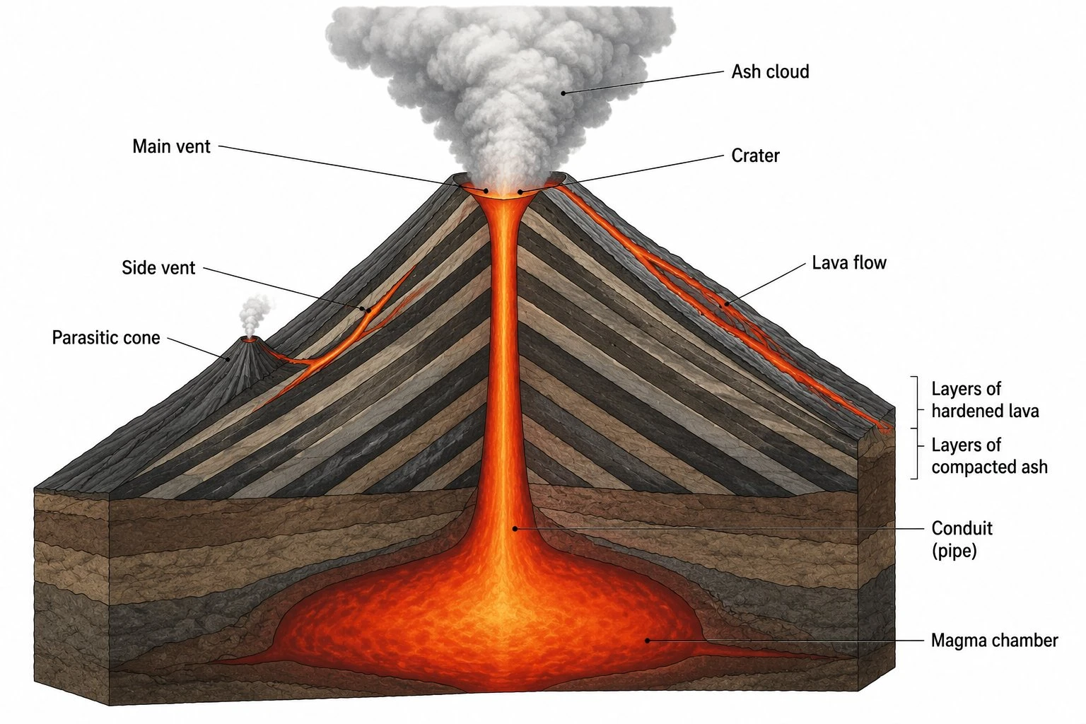
Volcano Diagram Generator
Generate labeled volcano diagrams showing the magma chamber, conduit, vent, crater, lava flows, and ash cloud — or compare shield, composite, and cinder cone types.
 Earth Science
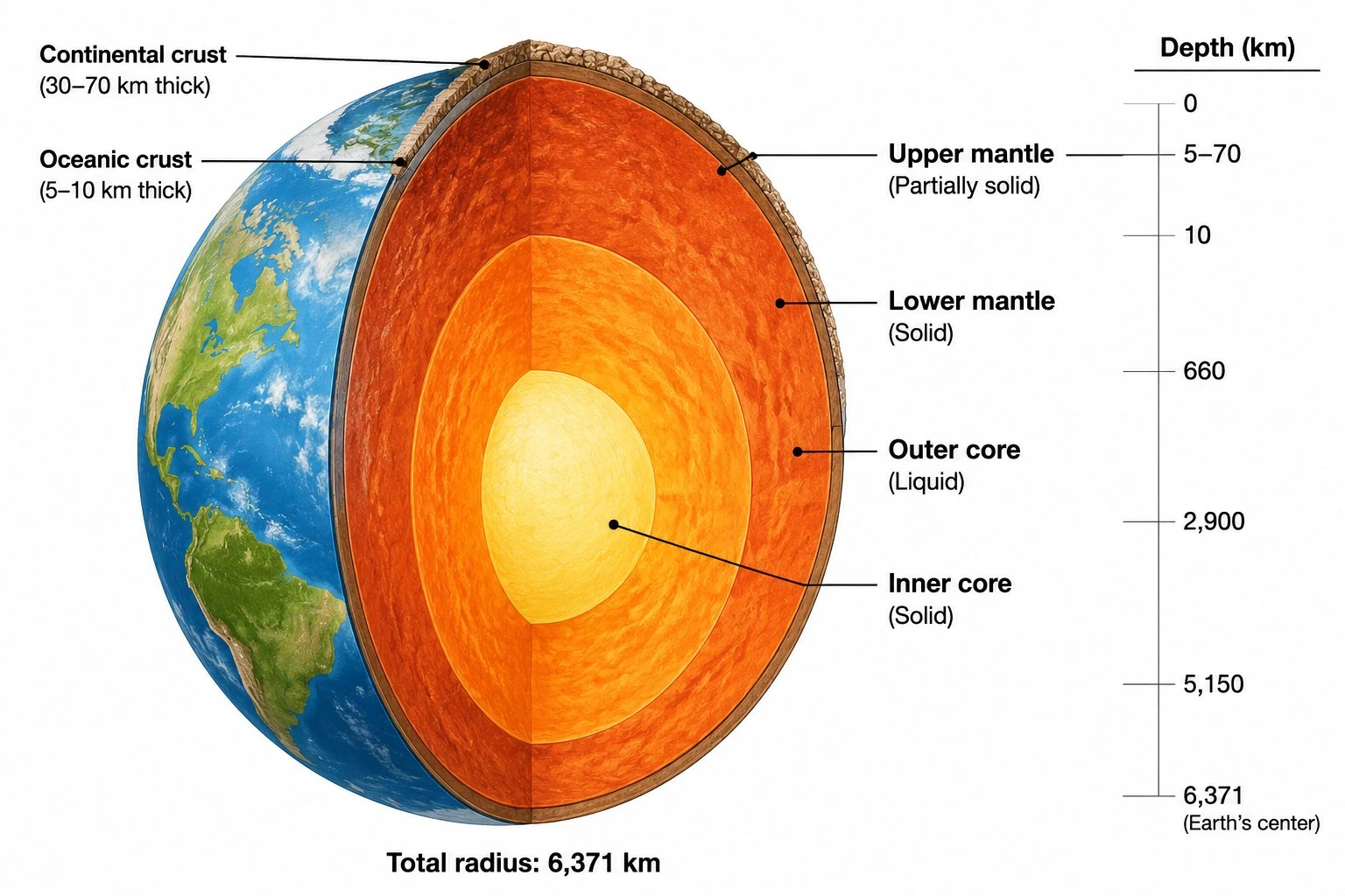
Layers of the Earth Diagram Generator
Create a labeled layers of the earth diagram showing the crust, mantle, outer core, and inner core with depth, temperature, and state of matter for each layer.
 Earth Science
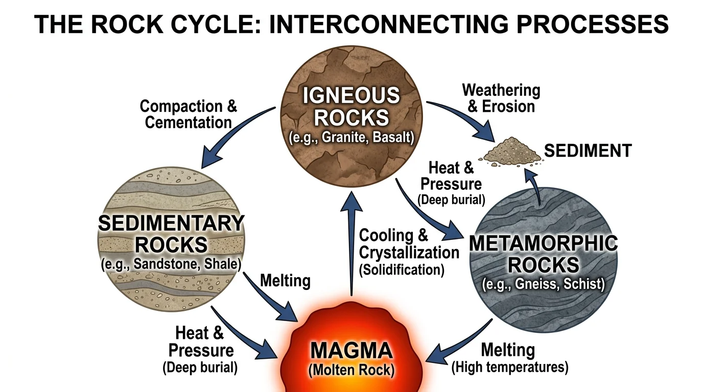
Rock Cycle Diagram Generator
Create labeled rock cycle diagrams showing igneous, sedimentary, and metamorphic rocks and the processes that connect them.